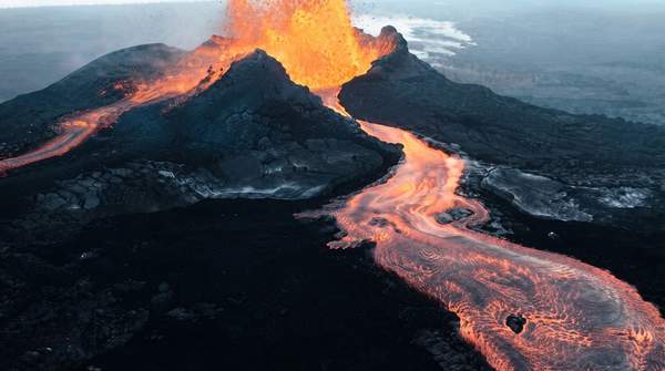
Earth's crust is reshaped at three kinds of plate boundaries, and each one leaves a distinctive signature on the landscape. Where plates pull apart, new oceanic crust is born along mid-ocean ridges and rift valleys. Where they collide, crust is destroyed or crumpled upward into trenches, volcanic chains, and mountain ranges like the Himalaya. Where they slide past one another, the crust is neither created nor destroyed, but ground into fault valleys and offset across the boundary. Learning to read those signatures is the key to understanding earthquakes, volcanoes, and mountain building around the world.
Introduction to Plate Tectonics and Boundaries
The Earth's outer shell is broken into tectonic plates composed of oceanic lithosphere and the thicker continental lithosphere, each topped by its own kind of crust. These plates are not static: their relative movement typically ranges from zero to 10 centimeters annually. Almost nothing dramatic happens in the middle of a plate. Instead, the action concentrates along the boundaries where plates interact, which tend to be geologically active, producing earthquakes, volcanic activity, mountain-building, and oceanic trench formation.
As National Geographic explains, sections of Earth's crust can come together and collide (a "convergent" plate boundary), spread apart (a "divergent" plate boundary), or slide past one another (a "transform" plate boundary). Each type is associated with different geological features, which is why a mid-ocean ridge, a deep trench, and a linear fault valley each point to a different kind of plate interaction. The rest of this article unpacks each boundary in turn, then places all three side by side for comparison.
Divergent Plate Boundaries: Where New Crust Forms
At a divergent boundary, two plates move away from each other. As they separate, the crust stretches and thins, forming a narrow rift valley where geysers spurt superheated water. Magma—molten rock—rises from the mantle to fill the gap and solidifies into basalt, creating new oceanic crust. Earthquakes are common along these boundaries, and volcanic activity is typically effusive rather than catastrophic, since the molten rock generally escapes through fissures rather than building pressure.
The most spectacular example is the mid-ocean ridge system, which National Geographic describes as Earth's longest mountain range: a divergent boundary roughly 65,000 kilometers (40,390 miles) long and 1,500 kilometers (932 miles) wide. The Mid-Atlantic Ridge is one segment of this system, and in Iceland it rises above sea level, letting visitors stand between the diverging North American and Eurasian plates. The pace is slow but relentless: the National Park Service notes that as Europe and Africa move away from the Americas at about 1½ inches (4 centimeters) per year, the Atlantic has opened to a width of 4,000 miles (6,000 kilometers) over the past 150 million years.
Convergent Plate Boundaries: Collisions and Subduction
At a convergent boundary, two plates move toward each other and collide. The impact can buckle the edges of one or both plates upward into mountain ranges, or bend one plate downward into a deep seafloor trench. Convergent boundaries can involve oceanic-oceanic, oceanic-continental, or continental-continental interactions, and the resulting landforms depend on which combination is involved.
The defining process here is subduction: one plate slides beneath another and descends into the mantle. Where an oceanic plate meets a continental plate, the denser oceanic crust is forced down, begins to melt, and the melted rock rises through the overlying plate as magma, often forming a chain of volcanoes parallel to the boundary. Volcanic activity at convergent boundaries is often explosive due to trapped gases, and powerful earthquakes are common. The Pacific Ring of Fire is the classic example of this boundary type. When two continental plates collide instead, neither descends readily: the boundary between the Indian and Eurasian plates has crumpled and pushed the crust upward into the towering Himalaya. In short, convergent boundaries destroy oceanic crust even as they build mountains and volcanoes.
Comparative Table of Plate Tectonic Boundaries
The table below systematically categorizes each boundary type by its defining motion, its effect on the crust, and the geological features and events it produces. Use it to move from an observed landform back to the plate interaction that created it—or from a known boundary type to the features you should expect to find there.
| Boundary Type | Plate Motion | Effect on Crust | Geological Features & Events | Real-World Example |
|---|---|---|---|---|
| Divergent | Plates pull apart, or spread away from each other | New crust is generated as magma rises from the mantle and solidifies into basalt | Mid-ocean ridges, rift valleys, effusive volcanoes, earthquakes | Mid-Atlantic Ridge, visible above sea level in Iceland |
| Convergent | Plates collide or come together (oceanic-oceanic, oceanic-continental, or continental-continental) | Crust is destroyed through subduction, or crumpled and uplifted | Deep seafloor trenches, volcanic chains, mountain ranges, powerful earthquakes, often explosive volcanism | Pacific Ring of Fire; the Himalaya at the Indian-Eurasian plate boundary |
| Transform | Plates slide past one another | Crust is neither created nor destroyed; it is displaced and pulverized along the boundary | Linear fault valleys, undersea canyons, offset structures, earthquakes | San Andreas fault zone, which extends underwater |
The pattern that emerges is a simple conservation logic: divergent boundaries create crust, convergent boundaries destroy it, and transform boundaries conserve it while displacing everything that crosses their path. That logic lets you predict the features you will find at any boundary once you know the direction of plate motion.
Understanding the Geological Consequences
The third boundary type completes the picture. At a transform boundary, two plates grind horizontally past each other. NOAA notes that structures crossing such a boundary—natural or human-made—are offset, split into pieces and carried in opposite directions, while rocks lining the boundary are pulverized, creating a linear fault valley or undersea canyon. The San Andreas fault zone is the most famous example. Because the plates are locked together by friction and then lurch past each other in sudden releases, transform boundaries are notorious earthquake producers, even though they build neither mountains nor new seafloor.
Connecting the three types explains the global distribution of hazards. The mid-ocean ridge, the planet's longest mountain range, is a divergent feature where new seafloor is continuously manufactured. The Pacific Ring of Fire concentrates the world's most explosive volcanoes and most powerful earthquakes above subduction zones, where ocean crust returns to the mantle. And the San Andreas fault illustrates what happens when plates simply refuse to move past each other smoothly. Each landform is a diagnostic clue: a rift valley means plates are pulling apart, a trench-and-volcano pairing means one plate is diving beneath another, and an offset stream or fault valley means plates are sliding past one another.
Identifying Plate Boundary Features
When observing a geological feature, identify its associated plate boundary type by recognizing the characteristic plate motion and crustal effect. A ridge or rift signals divergence and crustal creation; a trench, volcanic arc, or collision mountain range signals convergence and crustal destruction; a fault valley or offset feature signals transform sliding. The measurable indicator is the presence of mid-ocean ridges, rift valleys, deep ocean trenches, volcanic arcs, or major fault lines—each one a direct, observable record of which of the three plate interactions shaped that corner of the Earth.